Saturday, February 4, 2012

A Scottish Journey (Part 4) - Galloway Forest Park and Food

GALLOWAY FOREST PARK

This panorama was taken in Galloway Forest Park. It was taken from Bruce’s Stone which overlooks Loch Trool. The stone commemorates the victory of Robert the Bruce and his men over the English near this spot in 1307.


Galloway Forest Park is similar to a State Park in the USA. This park is very hilly and forested with numerous streams, waterfalls, and cascades. This stream and bridge are by the visitor’s center for the park.


This cascade is just down stream from the bridge in the previous photo. It was raining the entire time I was in Galloway Forest Park.


I went for a hike on a trail up a valley toward the top of a mountain/hill (Merrick). The trail, seen in the above photo, was narrow and often included water running downhill toward me (due to the rain). It didn’t take long before my sneakers and socks were completely soaked. But I would do it again. I made the best of the time I had, rain or shine (mostly rain).


There was a raging stream coming down the small valley that I hiked up. After coming back down I went further down hill into some woods. This was what the stream looked like in the woods near a small bridge. The stream was “squeezed” between the rocky outcroppings to make a small waterfall. There were a lot of ferns and mosses growing on the rock walls.


This was a single-lane bridge crossing the small stream (The small waterfall in the previous photo is about 30 feet to the left of the bridge). This forest, road, and bridge reminded me of something that would be seen in a Robin Hood movie set in Sherwood Forest.


FOOD

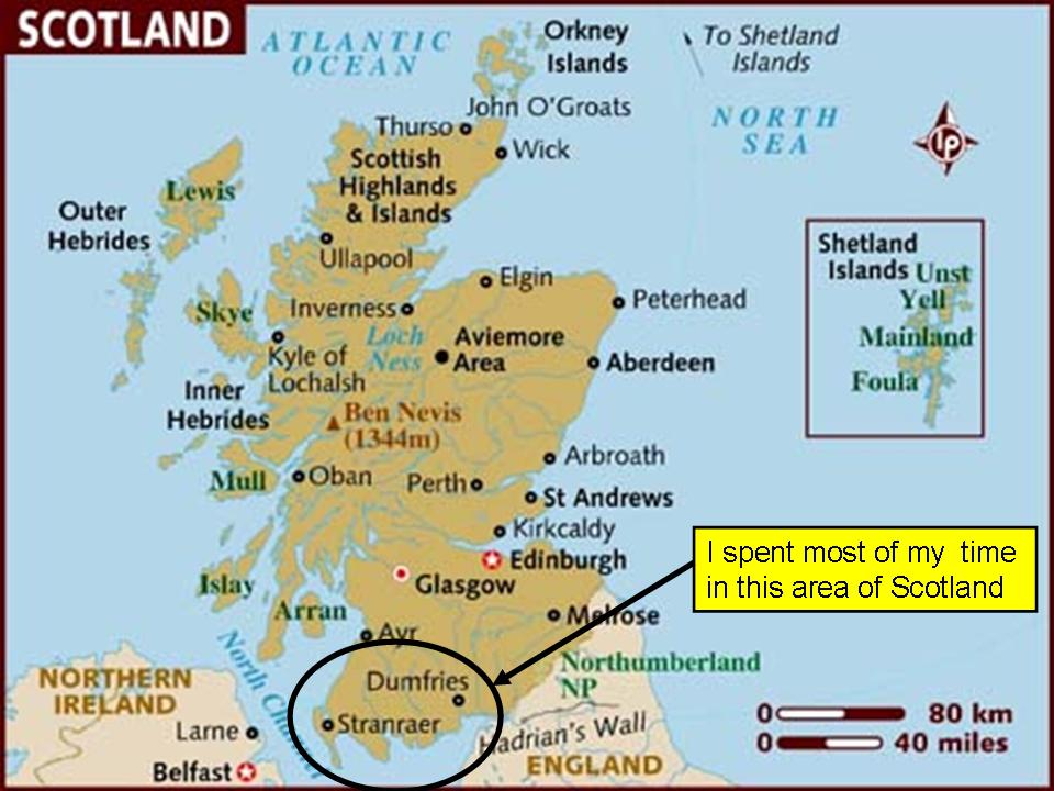
I thought I would end with a little about the food. I tried to eat the local cuisine as much as possible. I tried a few new things. The above photo was my first meal in Scotland at a small restaurant in Stranraer. This was breakfast at lunchtime. The only odd thing was baked beans for breakfast.


A “traditional” Scottish food is haggis. This is the haggis that I had in Stranraer (the dark stuff on the left). According to Wikipedia it is a “savoury pudding containing sheep's 'pluck' (heart, liver and lungs), minced with onion, oatmeal, suet, spices, and salt, mixed with stock, and traditionally encased in the animal's stomach”. I had it served the traditional way with "neeps and tatties" (Swedish turnips and mashed potatoes). I ate haggis this one time, but didn’t have it again. I had “black pudding”, also known as “blood sausage”, twice for breakfast. It was okay. A few other things that I had were fish and chips, steak pie, and a “ham roll” (just ham in a roll) and chips. Overall the food wasn’t all that great.

A Scottish Journey (Part 3) - Lighthouses and Birds

LIGHTHOUSES

This panorama is of the town of Portpatrick on the western coast of the south-western part of Scotland. It is a very small town which has a protected harbor and a small lighthouse (to the left) – more on it below.


Mull of Galloway Lighthouse: There were quite a few lighthouses in the area of Scotland where I worked. This one is on the Mull of Galloway on the extreme southwestern tip of Scotland. It was first lit in 1830. This peninsula has 300 ft cliffs and the lighthouse is 85 ft high. I climbed the 114 steps to get the view from the top. Unfortunately it was somewhat overcast so I couldn’t see more than a mile or so.


This is not a lighthouse, but it is a photo of the Mull of Galloway cliffs. I took this in the opposite direction from the previous photo of the Mull of Galloway lighthouse. It was good the sign was there because I hadn’t noticed the dangerous cliff. : )


Portpatrick Lighthouse: This lighthouse is a small one in the town of Portpatrick on the south-west coast nearest to Ireland. The town rings a small harbor. We explored the town for a little while and then got chased away by rain. The sea was very rough this day and the waves were crashing on the rocky coast.


Corsewall Lighthouse: This lighthouse is located on the northern tip of the peninsula northwest of Stranraer. I had to take this narrow, single lane road to get to the remote lighthouse, which is now a luxury hotel. It was built in 1817 by Robert Stevenson, the grandfather of the famous writer Robert Louis Stevenson. Visits with his father to remote lighthouses are thought to have inspired his books “Kidnapped” and “Treasure Island.”


This shot of Corsewall lighthouse was taken as the clouds broke up and the sun came out right before it set. It was one of the few times I saw the sun during my two week visit to Scotland.


Southerness Lighthouse: This “square” lighthouse is located on the southern coast of Scotland on the Solway Firth (A firth is kind of like a bay or river estuary). The “beach” was a wide expanse of tilted sedimentary rocky layers. I could only take photos from this angle since the wind was at my back and I was trying to protect my camera from the rain that was falling/blowing.


BIRDS

While in Scotland I got to see a few bird species I had never seen before. I’m still not entirely sure what these are, but I think they are immature kittiwakes. I shot these on the sea wall in Stranraer.


This is a pied wagtail. It would bob its tail up and down, hence the name. I saw this bird in Stranraer in a park by the shore of Loch Ryan.


I shot these oystercatchers along the western shore of Loch Ryan.


These barnacle geese spend the winter at several locations in Scotland. I visited the Mersehead Nature Reserve which is administered by the Royal Society for the Protection of Birds (RSPB). The geese had just started returning about a week before I visited the reserve.

A Scottish Journey (Part 2) - Castles and Other Old Buildings

CASTLES AND OTHER OLD BUILDINGS

This panorama is not a castle, but an abbey - more about it below. There are a lot of ruins in this area of Scotland. I believe this is the result of two things. First, many of these structures (castles and abbeys) were built in the 1400s and 1500s. So they are very old. Second, many of these structures were sacked as a part of the English invading Scotland. This happened fairly frequently over the centuries. There are some castles that have been restored and are nicely furnished. I didn’t go to any of those. I preferred the ones that were in ruins or at least not fancy.


Castle St. John in Stranraer: It was built in about 1511. I was not able to go inside since it closed for the season two days before we arrived in town.


Maclellan’s Castle: This castle was built is the 1570s. It is located in the town of Kirkcudbright. It was also closed for the winter (as of Sept. 30th).


Cardoness Castle: This castle was built in the 1500s. I didn’t take the time to go in this one…so many castles, so little time.


Dunsky Castle: We had to take a short hike up a hill and along the coast to get to this castle built in 1510. It is located just south of the town of Portpatrick. The yellow flowers in the foreground are on a gorse plant. It is a fairly “spiky” plant and it seemed to be used a lot as a hedge row.


This shot was taken inside a portion of Dunsky Castle.


Orchardon Castle: According the “Historic Scotland” information this is the only round tower house castle in Scotland. It was built in the 1500s. I was pleasantly surprised to find that it was open. I was able to go in the “basement” storage area in the door on the right and in the “first floor” up the stairs on the left side.


I was extremely surprised to find a small doorway in Orchardon Castle that led to this very tight spiral staircase that led up to the top of the tower. There was a great view of the surrounding countryside from up there. I also saw a ring-necked pheasant while visiting this castle. The pheasant and country-side reminded me of central Pennsylvania.


Edinburgh Castle: Travis and I had to make a work-related “emergency” drive to Edinburgh (about a 2.5 hour drive). We got there late one evening and left before lunch the next day, so we didn’t get to see much. However, we did walk around a small portion of the “Royal Mile” portion of the city for about an hour. Ian, another co-worker that was already in Edinburgh, was kind enough to be our tour guide. This photo is of the Edinburgh castle which is on a rocky outcropping in the middle of the city. I really wanted to explore the castle, but it was closed at night. Maybe next time…if there is one.


There are quite a few old abbeys in the southern part of Scotland. Many were destroyed in past centuries by invaders from the south (from England). This is the Dundrennan Abbey which was built in 1142. Mary Queen of Scots spent her last night in Scotland here in 1568 before being exiled to England. The circular gray “spots” in the grass in the central-left part of the photo are where the vertical columns rested that held up the roof in the main hall.


This photo shows me (proving I was really there : ) ) beside the base of one of the columns that held up the roof of Dundrennan Abbey. It was very impressive how well built the remaining walls and arches were (behind me).


I visited the Kirkmadrine Church which is a newer church building built on the site of an older church. It is surrounded by a cemetery and is located out in the middle of a field (but is bordered by a stone wall). The “porch” of the church houses the Kirkmadrine “Christian Stones”. The earliest of these stones is a pillar dating from the 400s or 500s and contains a Latin inscription.


I thought this door and stone wall on the side of the Kirkmadrine Church building had a lot of character.

A Scottish Journey (Part 1) - Overview, Stranraer, Loch Ryan and Mull of Galloway

OVERVIEW

As many of you know, I (David) went to Scotland on business in October 2011. While I worked much of the time I was able to see some of the sights in the surrounding area. The following are a few photos (of the 2600 that I took during the two weeks I was there) highlighting what I was able to see. Most of the time the weather was poor (overcast, rainy, windy) so the photos aren’t great. But I had fun seeing a country I had never been to before and exploring new things (often in the rain).

I spent my time in the extreme southwestern portion of Scotland in the region referred to as Dumfries and Galloway. I stayed in a town named Stranraer (pronounced Stran-raw). It is situated on the southern end of Loch Ryan and currently is the ferryport for the ferry to Belfast and other locations. Before this trip I thought a loch was like a lake, and it is, but it can also be a bay. Loch Ryan is a body of water that is salty and opens into the Irish Sea.

The area around Stranraer is mostly rural farmlands. Some areas reminded me of Pennsylvania. There were a lot of rolling hills in this area. I was hoping to get to the northern part of the country to see the Scottish highlands, but the weather did not cooperate. So all of my travels were in the southwestern portion of the country.


This is a map that shows the area in which I worked and traveled during most of my stay in Scotland.


STRANRAER, SCOTLAND

This is a panorama of a portion of the town of Stranraer at the south end of Loch Ryan. The large, white building slightly left of center is the hotel where I stayed. It is named the Northwest Castle, not to be confused with the Castle of St. John which is also in Stranraer and is the tall structure near the right edge of the photo.


This is a nighttime shot of one of the narrow streets of Stranraer near the town center. A car’s headlights made the double white streaks.


Stranraer is a harbor town and has many fishing boats and pleasure craft. This is a shot of a few of the well-used, but colorful fishing boats in the harbor.


Our hotel had a curling facility attached. Supposedly this was the first hotel in the world to have one. As a part of a national initiative to encourage interest in curling they were offering free curling lessons. My co-worker and I were able to attend two sessions. It was tricky, but a lot of fun.


My co-worker, Travis, took this shot just after I pushed off the “hack” (the black foot block behind me) in the process of “throwing” a stone. There is a special Teflon foot slide that we slid on to throw a stone. The experts have special shoes. The handle on the stone is used to rotate or “curl” it to make it go where intended.


LOCH RYAN AND MULL OF GALLOWAY

This panorama is of Loch Ryan. The town of Stranraer is to the right, behind the ferry. Loch Ryan is enclosed by land except for an opening on the north end. This opens onto the Irish Sea. This opening can be seen toward the left-center of the photo at the break in the hills.


This is a ferry heading south in Loch Ryan (toward Stranraer). Together this shower out over the Loch and one of the few times when the sun was visible converged to produce the intense rainbow. At least the orange and blue that I can see are intense. I assume the other colors are intense also. : )


This photo was taken from the west side of Loch Ryan looking across to the hills on the east side.


This was a typical countryside scene in the south-west portion of Scotland. There is a lot of green grass and there are a lot of stone walls separating fields.


There were some cattle and lots of sheep in the area of Scotland in which I worked and traveled. The body of water in the distance is the Irish Sea and the large granite outcropping in the water is Ailsa Craig. The granite from this is used to produce curling stones.


This is a coastal scene on the “Mull of Galloway”. This is the peninsula on the extreme south-west end of Scotland. This was shot on the way to the Mull of Galloway lighthouse.


This Scottish bovine managed to impede my progress down the single lane road on the way to the Mull of Galloway lighthouse. Apparently he can’t “read” the sign.


As mentioned previously I worked in a rural/farming area. We passed by this farm on the way to work every day. It seemed funny to have a stereotypical red British phone booth out in the country (one of the few that I saw in my travels).